The Baldwin Road Development Plan was endorsed on 25 August 2025.
The Baldwin Road Development Plan applies to land north of Baldwin Road in Traralgon, identified as a key residential growth area in the Latrobe Planning Scheme. It guides the coordinated subdivision and development of this land to support a well-planned and connected community that aligns with Council’s broader growth objectives.
This area was earmarked for urban expansion in the Traralgon Town Structure Plan, which identifies preferred locations for new residential development. The Baldwin Road area will accommodate a mix of residential lots and public open spaces to meet the needs of future residents.
The Development Plan Overlay – Schedule 11 (DPO11) applies to this area and requires a Development Plan to be approved before any permits for subdivision can be issued. This ensures integrated planning that considers infrastructure delivery, open space provision, and environmental outcomes from the outset.
Once finalised, the Baldwin Road Development Plan will provide a framework for a sustainable and vibrant residential community—connecting to existing neighbourhoods and integrating green spaces that promote an active lifestyle.
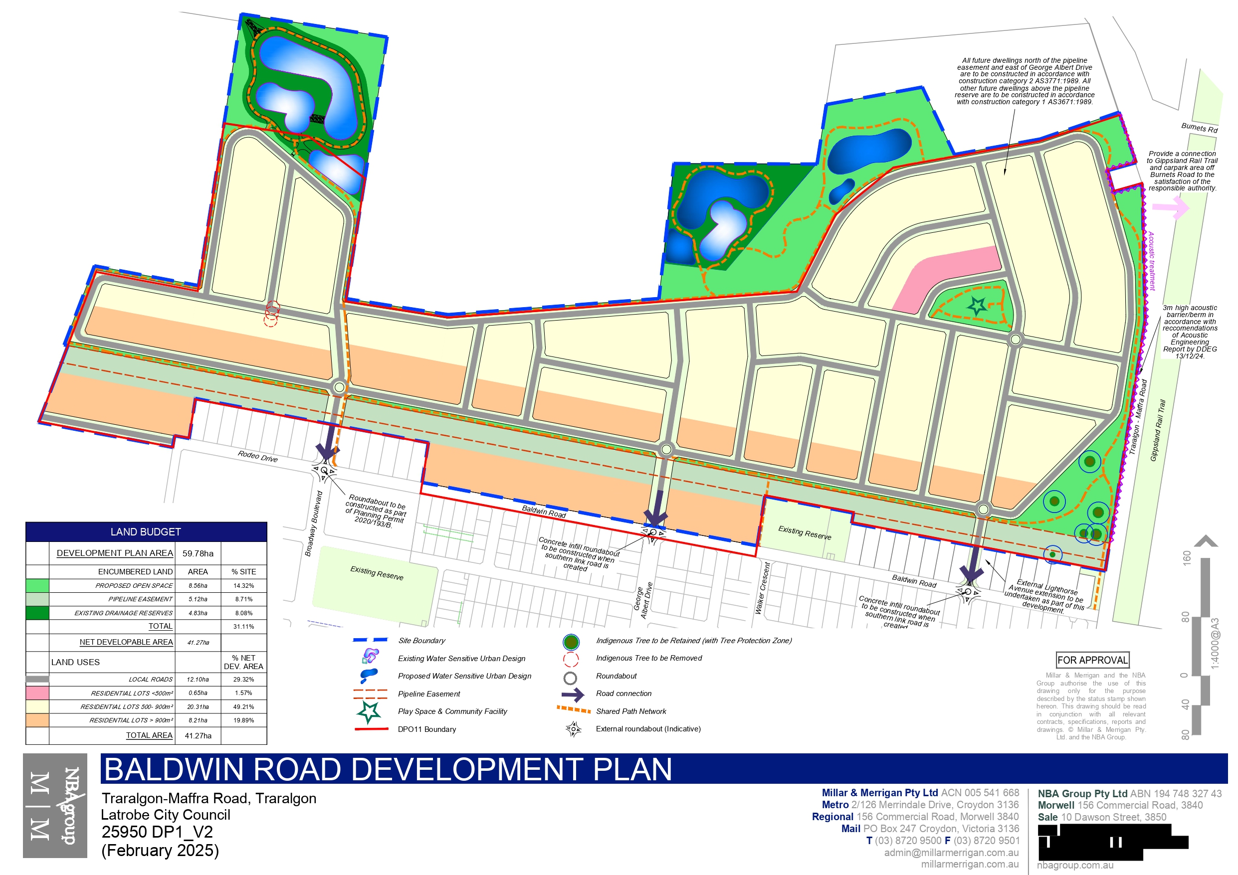
The Development Plan applies to the land shown in Figure 1 below.
What does Baldwin Road Development Plan do?
The Baldwin Road Development Plan sets out a detailed and coordinated approach to the subdivision of land north of Baldwin Road. It:
- provides a cohesive subdivision layout;
- identifies essential infrastructure such as roads, drainage, and utility services; and
- specifies public open spaces, including parks and recreational areas.
Current Stage: Consideration of submission by Council officers
Further Information
Please contact a member of the Urban Growth Team on 1300 367 700 for any enquiries relating to the Baldwin Road Development Plan.
Related Documents
Development Plan Documents
Draft Baldwin Road Development Plan - Map
Draft Baldwin Road Development Plan - Report
Appendix 1 – Certificate of Titles
Appendix 2 – Site and Context Description 1
Appendix 2 - Site and Context Description 2
Appendix 2 - Site and Context Description 3
Appendix 4 – Streetscape Cross Sections Plan
Appendix 6 – Locality Context Plan
Appendix 7 – Open Space Contribution Plan
Appendix 8 – Bushfire Management Plan
Appendix 9 – Landscape Masterplan
Appendix 10 – Infrastructure Services Report
Appendix 11 – Stormwater Management Strategy 1
Appendix 11 – Stormwater Management Strategy 2
Appendix 12 – Safety Management Study Report
Appendix 14 – Native Vegetation Report
Appendix 15 – Terrestrial Fauna Assessment
Appendix 16 – Aquatic Targeted Survey
Appendix 17 – Cultural Heritage Due Diligence
Appendix 18 – Acoustic Engineering Report
Appendix 19 – Air Quality Assessment
Appendix 20 – Community Infrastructure Needs Analysis