Amendment C126 implements the findings of the Toongabbie Structure Plan report and background reports, and the recommendations from the West Gippsland Catchment Management Authority 2016 Flood Study for Toongabbie into the Latrobe Planning Scheme.
An interactive map tool is available to search addresses and view how the amendment may propose to change land in Toongabbie:
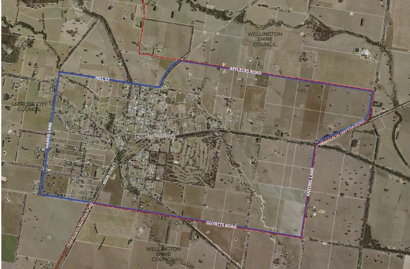
Where does the Amendment apply?
The amendment applies to approximately 850 Hectares of land in Toongabbie within the Toongabbie Township Boundary defined on the Toongabbie Structure Plan. It is bounded by Harris Lane, Guyatts Road, Antons Lane, Traralgon-Maffra Road, Afflecks Road, Hill Street and Gippsland Plains Rail Trail as shown in Figure 1 (the blue line represents the Toongabbie Township Boundary in the Toongabbie Structure Plan 2020).
What does Amendment C126 do?
The amendment proposes a range of changes to the Latrobe Planning Scheme, specifically the Amendment proposes to:
Planning Policy Framework
- Amend Clause 11.01-1L (Local Areas) to include the Toongabbie Structure Plan, insert key strategies and policy documents.
- Amend Clause 12.01-1L (Protection of Biodiversity) to include key strategies and policy documents for Toongabbie.
- Amend Clause 16.01-1L (Housing supply) to include the amended Toongabbie Housing Framework Plan.
Zones
- Rezone residential land from Neighbourhood Residential Zone – Schedule 4 to Neighbourhood Residential Zone – Schedule 5.
- Rezone land at 52 Ries Street (CA 1A Section A Toongabbie), 49-57 Heywood Street (CA 1B Section A Toongabbie), 23-33 Heywood Street (L 2 PS 330744), 21 Heywood Street (L1 PS 330744), 81 Main Street (L1 PS 711191), 79 Main Street ((L2 PS 711191), and 77 Main Street (CA 2 Section 29 Toongabbie) from Neighbourhood Residential Zone – Schedule 4 to Low Density Residential Zone.
- Rezone King Street Toongabbie (CA 2 Section 3A Toongabbie and CA 4 Section 3A Toongabbie) from split zoned Farming Zone – Schedule 1 and Neighbourhood Residential Zone – Schedule 4 to Low Density Residential Zone.
- Rezone 19-29 Hower Street (CA 11 Section 9 Toongabbie) and 9-17 Hower Street (CA 5 Section 14 Toongabbie) from Farming Zone – Schedule 1 to Low Density Residential Zone.
- Correct the split zoning at 15-25 Victoria Street from Public Use Zone – Schedule 2 and Neighbourhood Residential Zone – Schedule 4 to Public Use Zone – Schedule 2.
- Rezone land at 15 Cowen Street (only L1 LP 116911), 17 Cowen Street (L2 LP 116911), 11 Victoria Street (CA 6 Section 17 Toongabbie), 12 Victoria Street (CA 6 Section 16 Toongabbie), 8 Victoria Street (CA 4 Section 16 Toongabbie), 6 Victoria Street (L 1 PS 423649), 4 Victoria Street (L 2 PS 423649), 2 Victoria Street (CA 10 Section 16 Toongabbie) and 1-5 Goodwin Street (L3 PS 423649) from Neighbourhood Residential Zone – Schedule 4 to General Residential Zone – Schedule 4.
- Rezone Main Street Toongabbie (CA 85A Toongabbie), Traralgon-Maffra Road (CA 9A Section A Toongabbie), Traralgon-Maffra Road (CA 32C Toongabbie), Russells Road (CA 5A Section 3A Toongabbie), Russells Road (CA 5 Section 3A Toongabbie), Humphrey Road (CA 2004 Toongabbie) and Hower Street (CA 2005, CA 2006 Toongabbie) from Farming Zone - Schedule 1 to Public Conservation and Resource Zone (PCRZ).
Overlays
- Amend the Land Subject to Inundation Overlay to include areas identified within the Floodplain Mapping for Toongabbie Township West Gippsland Catchment Management Authority (WGCMA, 2016).
- Introduce the Floodway Overlay to areas identified within the Floodplain Mapping for Toongabbie Township (WGCMA, 2016).
Operational Provisions
- Amend Clause 72.08 (Operational Provisions) to include the Toongabbie Structure Plan Report, and Toongabbie Structure Plan Background Reports as background documents.
Current Stage: Approval and Gazettal
The amendment was approved by the Minister for Planning on 22 June 2023.
The amendment was placed in the Government Gazette on 29 June 2023 and now forms part of the Latrobe Planning Scheme.
Further Information
Please contact Strategic Planning on 1300 367 700 for any enquiries relating to Planning Scheme Amendment C126.
Related Documents
Related Links
- Ordinances
- Zone Map
- Overlay Maps Amended
- Overlay Maps Deleted